Trail Cycle Le Wast - La vallée du Wimereux - Le Wast - Photo

La vallée du Wimereux - Le Wast

 tracegps
tracegps

User

© OpenStreetMap contributors
Length
Length
30 km
Max alt
Max alt
110 m
Uphill gradient
Uphill gradient
337 m
Km-Effort
Km-Effort  
35 km
Min alt
Min alt
18 m
Downhill gradient
Downhill gradient
336 m
Boucle
Boucle
Yes
Creation date :
2014-12-10 00:00:00.0
Updated on :
2014-12-10 00:00:00.0

(0 Reviews)

Cycle
Cycle
3h00
Difficulty : Medium

Scan this QR Code to open this trail in the SityTrail application

FREE GPS app for hiking

Logo SityTrail SityTrail

IGN / Geographical institutes

Download SityTrail from the App Store Download SityTrail from Google Play

Logo SityTrail SityTrail World

The world is yours!

Download SityTrail from the App Store Download SityTrail from Google Play Download SityTrail on Huawei AppGallery

About

Trail Cycle of 30 km to be discovered at Hauts-de-France, Pas-de-Calais, Le Wast. This trail is proposed by tracegps.

Description

Circuit proposé par le Parc naturel régional des caps et Marais d’Opale . Départ de la place du village de Le Wast. Au milieu d’un paysage vallonné et bocager, cet itinéraire vous entraîne à la découverte d’éléments remarquable du patrimoine architectural boulonnais. Cet itinéraire se distingue par un balisage spécifique et n’emprunte que des voies macadamisées. Retrouvez le circuit dans le livret 2010 du Parc naturel régional des Caps et Marais d’Opale. Ce circuit a été numérisé par les randonneurs du CODEPEM.

Elevation profile

Photos

Positioning

Country:
France
Region :
Hauts-de-France
Department/Province :
Pas-de-Calais
Municipality :
Le Wast
Location:
Unknown
Start:(UTM)
415425 ; 5622681 (31U) N.

Trails nearby

Trail Walking Colembert - Les mille monts de Colembert - Photo
Walking
Baltykatt

Walking

Difficult
(1)
Colembert, Hauts-de-France, Pas-de-Calais, France
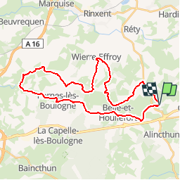
27 km | 34 km-effort
7h 15min
Yes
Trail Walking Boursin - Sentier du Funquet  - Photo
Walking
Baltykatt

Walking

Easy
(3)
Boursin, Hauts-de-France, Pas-de-Calais, France
10.9 km | 13.3 km-effort
2h 56min
Yes
Trail Walking Colembert - Colembert - Photo
Walking
delaine

Walking

Difficult
Colembert, Hauts-de-France, Pas-de-Calais, France
11.2 km | 13.4 km-effort
2h 36min
Yes
Trail Walking Conteville-lès-Boulogne - La Fontaine aux Charmes - Conteville-lès-Boulogne - Photo
Walking
tracegps

Walking

Easy
(1)
Conteville-lès-Boulogne, Hauts-de-France, Pas-de-Calais, France
5.8 km | 6.9 km-effort
1h 30min
Yes
Trail Walking Conteville-lès-Boulogne - La Fontaine aux Charmes - Photo
Walking
philippe.vdv

Walking

Medium
Conteville-lès-Boulogne, Hauts-de-France, Pas-de-Calais, France
6 km | 7.2 km-effort
1h 37min
Yes
Trail Walking Colembert - mont dauphin - Photo
Walking
Frédéric Vandaele

Walking

Very easy
Colembert, Hauts-de-France, Pas-de-Calais, France
5.3 km | 6.9 km-effort
1h 27min
Yes
Trail Cycle Le Wast - La vallée du Wimereux - Le Wast - Photo
Cycle
Baltykatt

Cycle

Medium
Le Wast, Hauts-de-France, Pas-de-Calais, France
30 km | 34 km-effort
3h 0min
Yes
Trail Road bike Wierre-Effroy - wierre Boulogne velo - Photo
Road bike
tenace

Road bike

Easy
Wierre-Effroy, Hauts-de-France, Pas-de-Calais, France
15.1 km | 17.9 km-effort
48min
No
Trail Walking Colembert - colembert - Photo
Walking
tenace

Walking

Medium
Colembert, Hauts-de-France, Pas-de-Calais, France
7.1 km | 9.2 km-effort
2h 49min
Yes


Close
My subscriptions